Database on Performance of High-Rise Reinforced Concrete Buildings in the 2015 Nepal Earthquake
Category
Uncategorized
Published on
Aug 31, 2016
Abstract
This database was last updated July 19, 2015.
Note: Additional data will be added to this database in the near future.
Note: Photo logs provided under the 'Drawings' column will be updated with precise locations where photographs were taken.
Note: Data were also collected for 146 low-rise reinforced concrete structures in Kathmandu, Nepal: Performance of Low-Rise Reinforced Concrete Buildings in the 2015 Nepal Earthquake
On April 25, 2015, a magnitude 7.8 earthquake occurred in Nepal. It caused more than 8500 casualties and left over 22000 people injured. Another major earthquake of magnitude 7.3 occurred in Nepal on May 12, 2015. Thousands of buildings were destroyed and many more rendered unsafe.
Detailed surveys and inspections of reinforced concrete structures affected by the earthquakes in Nepal were conducted in a reconnaissance effort funded by The American Concrete Institute. The effort was concentrated on identification of buildings with structures similar to new and older reinforced concrete buildings in seismic areas in the U.S. The reconnaissance group consisted of 4 teams (A, B, C and D) with 3 or 4 people in each team. Data were collected between June 18, 2015 and July 01, 2015.
 |
 |
 |
|
Locations where photographs were taken has been annotated on the drawings and building plans provided. For example, photograph name IMG_0038 corresponds to location 38 shown on the drawing/building plan. Photographs can be either viewed using the link provided in the 'Photos, Videos, etc.' column or can be downloaded from the zip file provided under the 'Data' column.
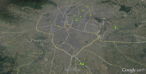
For detailed drawings and structural analysis models please refer to the zip folder under the 'Data' column. Damage level is depicted on the map as follows: Severe Damage in Red, Moderate Damage in Yellow and Light Damage in Green. The Google Earth (.kml) file for the map shown can be downloaded under the supporting documents tab. |

|
The following people are gratefully acknowledged for their help with data collection: Mukund Prasad Sah, Kamal Baral, Bishnu Paudel, Robin Guragain, Prakash Nepal, Ujjwal Karki, Amit Kumar Sah, Ajay Kumar Karna, Prakash Mishra, Sewak Pandit, Hari Krishna Dhamala, Tirtha Raj Timilsina, Bharat Budhathoki, Bipesh Shrestha, Shailesh Bhattarai, Radhey Shyam Chaudhary and Niranjan Shrestha.
Sincere thanks to the following for facilitating the data collection process:
|
This database is presented as a spreadsheet with each row containing the following information for a building:
- Title: Title of the project, group of experiments, simulations or surveys
- Source: Names of the people who generated the data
- Keywords: Words describing the dataset
- Report(s): Related documentation
- Experiment or Case ID: ID assigned by the source to the sample, specimen, case, survey, site, experiment or simulation
- Latitude: Latitude of the location where data was collected, if applicable
- Longitude: Longitude of the location where data was collected, if applicable
- Parameters: Variables and parameters chosen by the researcher, compiler, professional or scientific organization to describe the data
- Drawings/Diagrams: Drawing and diagrams helpful to interpret the data
- Data: Zip folders containing photographs, drawings and analysis models.
- Photos, Videos, etc.: Media files including photos, videos, audio generated through project
- Compiled by: Names of the people who compiled the data
- Date: Date when the dataset was compiled
In addition, the following information is presented in the parameter column:
- Event
- Building ID
- Number of Stories Above Ground
- Number of Stories Below Ground
- Structural Damage
a) Light: Hairline (crack width not exceeding approximate 0.13 mm) inclined and flexural cracks were observed in structural elements.
b) Moderate: Wider cracks or spalling of concrete was observed.
c) Severe: At least one element had a structural failure.
d) Collapse: At least one floor slab or part of it lost its elevation.
- Masonry Damage
a) Light: Hairline cracks occurred.
b) Moderate: Wider cracks appeared or large pieces of plaster flaked off.
c) Severe: The element collapsed or cracks wide enough to see through the wall appeared.
Cite this work
- Prateek Shah, Santiago Pujol, Aishwarya Puranam (2016), "Database on Performance of High-Rise Reinforced Concrete Buildings in the 2015 Nepal Earthquake," https://datacenterhub.org/deedsdv/publications/view/409.